It’s common in Charleston neighborhoods to see families driving golf carts to visit neighbors in other nearby subdivisions and parking their carts at local restaurants to enjoy a meal.
It’s less common to see on Johns Island, the once-rural sea island community 20 minutes from downtown Charleston, as historically there hasn’t been a large network of interconnected roads built between neighboring communities. This makes visiting restaurants and other neighborhoods impossible without traveling along the island’s major throughfares like Maybank Highway.
That has been changing slowly, as the city of Charleston has been requiring interconnected roads between new subdivisions since 2007 — a move a longtime land planner said will be a gamechanger for traffic on Maybank Highway in light of the new major developments planned for the three-mile length of Maybank Highway between River Road and Main Road.
They include:
- A free-standing emergency room proposed by Trident Health
- A medical park with doctor’s offices
- Low Tide Brewery relocating from its current location on Maybank Highway to a mile away on a large brewery campus with event space
- A Spinx gas station at Maybank Village
- Rhett’s Cove, a planned development that would bring 59 residences and commercial and restaurant space fronting Maybank Highway, according to a plan submitted to the city in 2021.
- Hayes Park, a mixed-use community with 55 units – 36 single family attached dwellings and 19 duplexes and townhomes, along with commercial space fronting Maybank Highway
- A new fire station for the city of Charleston
- A new city park proposed on 26 acres behind the Island School
- There’s also a new elementary school planned for River Road, currently under construction.
As new development has been changing the face of Maybank Highway, stakeholders and elected officials have been grappling with ways to quell traffic that is already a concern with standstill traffic on the thoroughfare during morning and evening rush hour.
A solution has been requiring developers to build interconnecting roads to nearby subdivisions that lessen driving dependence on Maybank Highway. An additional Johns Island Community Greenways Plan by the city of Charleston that would add walking trails and interconnected roads would supplement these efforts.
Related: Trident Health to build Charleston area free-standing emergency department
Related: Historic allure: Charleston area home sells for $9M
A report by the city Department of Planning, Preservation & Economic Innovation was presented at a Johns Island Community Planning Workshop in 2007, which acknowledged a lack of interconnected roads putting pressure on main throughfares.
“Conventional responses to this type of traffic congestion involve road widening and intersection enlargements. Because of the extraordinary canopy created by stands of trees along extensive portions of these main roads, the prospect of road widening is not acceptable,” the report states.
A citywide ordinance adopted in February 2007 states, “All subdivisions and developments shall include improved street connections to other streets within the development and to adjoining streets, neighborhoods, existing developments, developed tracts and undeveloped tracts.”
A roads plan decades in the making
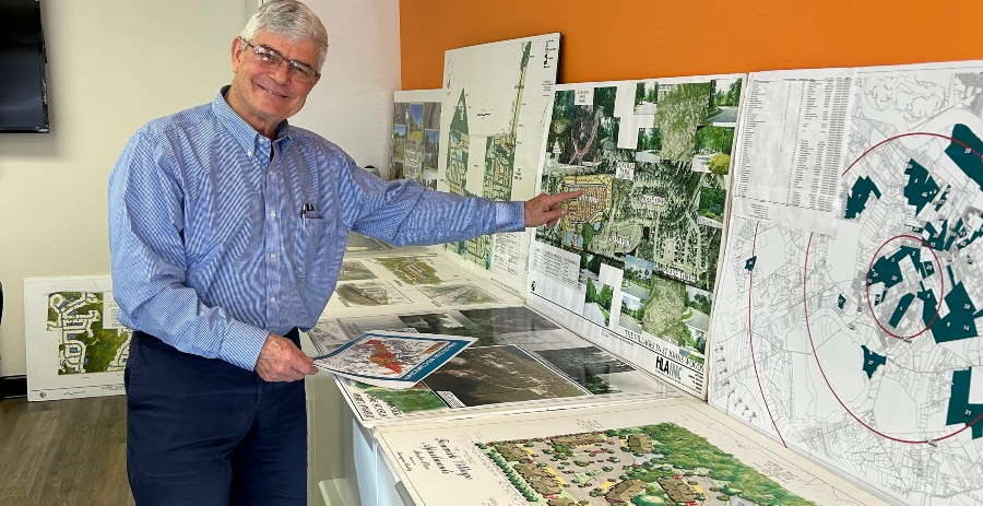
The interconnected roads plan for Johns Island was mapped out more than 30 years ago by HLA, a prominent land planning, landscape architecture, wetland permitting and civil engineering survey firm.
Barry Whalen, president of the company, helped create intentional interconnected road system in the 1980s, when he first began working with developers on surveying and land planning.
The proposed interconnected roads run parallel to the bustling Maybank Highway on both sides that would allow new communities to connect with established communities as well connect to the back of commercial developments that front Maybank Highway — suitable for walkability from communities and for using golf carts.
“Most people didn’t know that there was an intentional planning process. HLA has been proposing these interconnections in concert with projects in the city of Charleston and the county to make these happen,” Whalen said.
Whalen said the bigger picture is that these interconnected roads were outlined congruently with the idea that Interstate 526 (Mark Clark Expressway) would extend to and across the northeast corner of Johns Island, allowing for several additional ingress points to the island, a project that has been tied up for decades.
“I (have) drawings from 35 years ago that had the Mark Clark being considered,” Whalen said. “Ultimately, the combination of these interconnecting routes and larger scale road improvements (Main Road flyover, 526 completion) will make the island much more accessible.”
The problem came about when, while there was an outlined interconnected roads plan with multiple ingress and egress points for neighborhood communities, actually building interconnected roads was not required or enforced; it was more of a voluntary option, Whalen said.
“There was always the hope that working with the guidance of planning departments at the city and county that (developers) would participate, and market forces would demand to interconnect, (but) it’s been a slow process,” Whalen said. “Now it’s coming to a pitch where everyone is slowly wanting to connect.”
Slowly, HLA’s map of interconnected roads for both sides of Maybank Highway is moving from simply red slashes on paper to being executed in real life.
HLA continues to work with developers on Johns Island, both for current and yet-to-be-built projects, to outline interconnected roads and encourage connectivity, among other land planning services.
He said more developers are seeking advice on how to be responsible stewards of the island’s infrastructure and also noted that market forces are now incentivizing building interconnected roads — residents want to walk or take a golf cart to restaurants without getting on a busy throughfare.
Whalen is optimistic that an interconnected road system with these new Maybank Highway developments directly connecting to neighborhoods behind them — as well as the Johns Island Community Greenways Plan — will ease traffic, even as more major developments are announced.
“The idea is if you keep cobbling those interconnected roads together, instead of going up Maybank Highway, you’ll be able to go another route. That’s where you can have sidewalks and people can ride bicycles,” Whalen said.
Whalen helped inform the Johns Island community plan with the city of Charleston in 2007 and worked with the Charleston County School District on recommending the site location for the new elementary school on River Road, another island thoroughfare.
The new elementary school will include connectivity from the surrounding neighborhoods so that parents can drop off kids or they can safely walk to school without driving on River Road.
“A lot of people will be able to come internally (from back roads) with interconnecting neighborhood roads servicing the school and across from River Road,” Whalen said. There are also plans to put a traffic circle on River Road outside the new elementary school.
Whalen said that the success of the community is about how to manage growth responsibly moving forward, as the island is still not fully built out.
“Many more service providers are filling in to give island residents the ability to live, work, learn, eat, play and stay on the island,” Whalen said. “When the interconnected road system finally is fully interconnected, it will provide a community circulation network. The roads were always planned to happen, and they soon will.”
The post How interconnected roads are changing the future of development in Johns Island appeared first on Charleston Business.